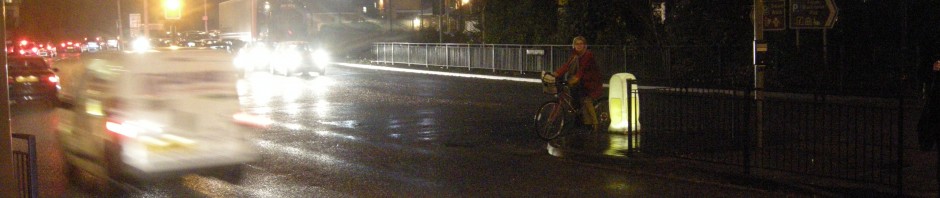
New Street is possibly one of the narrowest streets in Horsham. At the location shown in the picture below, the carriageway is 5 metres wide, with pavements of 2 metres and 1.5 metres wide, giving a total width of 8.5 metres.

At the northern end, it is about a metre wider – 9.5 metres – each pavement being 50cm wider. Unfortunately it is now, despite its width, something of a rat run. You can see in the map below that it forms an attractive shortcut for people travelling north to south in the town – or vice versa (New Street is the long straight road in the centre of the map).

The particular route I have marked is one I often encounter drivers using after picking up their children at St Mary’s school (point A), heading back to their homes in the north of Horsham. Instead of using the trunk roads of Park Way and North Street (the orange and yellow roads), which involve traffic lights, they have looked at a map and seen that the most direct route is along New Street, and several other residential streets, further east.
This kind of rat-running is totally inappropriate, given that the drivers are avoiding what I would call the ‘car-specific’ roads, designed to accommodate these kinds of journeys by car, and instead are forcing themselves through a narrow residential street. It’s all the more absurd given that this shortcut is, in reality, not at all quicker, because despite the absence of traffic lights, it involves several junctions, and the narrowness of New Street, allied to all the cars parked on it, means that it becomes clogged very easily by more than two drivers travelling in opposite directions. In practice this means that the frustrated drivers attempt to ‘make up time’ on the sections of their journey where they are not being held up by other cars, driving at inappropriate speeds on the more open sections of New Street, and the other residential roads.
Streets like New Street should be enjoyable to cycle on – it should be a quiet, residential street, with little motor traffic. In reality it is rather unpleasant to use on a bike, because of the inappropriate speed used by motorists in sections of it, as mentioned above, and also because some drivers think it is acceptable to drive towards you on a narrowed section like in the photograph that starts this post. I have often had to take to the pavement on this street, purely to avoid being squashed. I am also held up quite frequently as cars travelling in opposite directions negotiate their way through the parked cars on both sides of the street. New Street was actually the location for my Bikeability Level 2 lesson, and involved much ‘taking the lane’ and assertive cycling for my beginner companions; it really brought home to me how needlessly difficult it is to cycle on this kind of street.
So what is needed?
A Dutch solution. Here is Oosterhoutstraat in Assen.
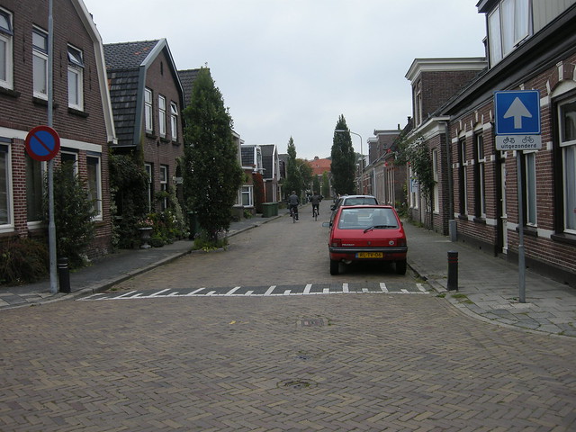
It is a residential street, of approximately similar width to New Street. It is slightly wider, at around 10 metres in total width, while the pavements are slightly narrower than those on New Street, about 1.5 metres. It is also very close to a station – Assen central station. It could form a useful shortcut across the city for drivers, travelling from the west, to the southeastern suburbs. But as you can see in the map below, it is not possible (or, more precisely, practical) to use Oosterhoutstraat as a route. In this first attempt, we are sent far to the south of Oosterhoutstraat (and the surrounding suburbs) –

Or, in this second attempt, we are sent on a different journey, to the north –

It simply isn’t practical to rat-run through Oosterhoutstraat.
Why is this? It’s partly through a combination of one-way streets in the surrounding residential area, that make it rather difficult to make direct journeys through this suburb. But mainly, it is through the closure of the eastern end of the road that would have emerged near point B on the map, Burgemeester Jollesstraat.
 Here’s what this junction looks like, as the road emerges onto the busy Overcingellaan –
 Presumably at some point in the past, this was a ‘normal’ road junction, but it is now accessible only by bike or by foot. The result is that the entire neighbourhood of Oosterhoutstraat is pleasant and quiet.
As it happens, it is still possible to use the street immediately to the south of Oosterhoutstraat – Bosstraat – as a rat-running route –
 But you would have to be pretty stupid to choose this as a route over the more southerly Port Natalweg, because Bosstraat looks like this –
 And Port Natalweg looks like this –
 A much wider and clearer road (although notice that the surface is composed of rough blocks to discourage fast driving).
Interestingly, we can see on Streetview that the layout on Bosstraat – designed to discourage it from being used as a through-route – is quite recent –
 As the Streetview car came past, the street was being redesigned to make it more difficult to drive through. It looks like the speed hump you can see in the picture of the finished Bosstraat is being added in the photograph above. Presumably drivers needed a little extra discouragement, to push them onto Port Natalweg.
The net effect of all these measures is to make this residential neighbourhood particularly quiet. We were on Oosterhoutstraat, and the surrounding streets, for around half an hour, and in that time I think we encountered no more than a handful of cars. This is because it is deeply impermeable to motor vehicle journeys – but, crucially, highly permeable by bike or by foot. Not only is there the direct access through the end of Burgemeester Jollestraat, but all the one-way streets in the neighbourhood are two-way for bicycles.

No entry, except (uitgezonderd) cycles. And the vehicles that are driving through here will travel slowly, because of the rough surface, speed humps, and tight radius corners, protected by bollards.
It would be very easy to apply precisely these solutions to New Street, to turn it from an unpleasant rat run, into a quiet street which is safe for pedestrians and bicycles. Most simply (and most cheaply), the northern end of the street, at the junction with Oakhill Road, could simply be closed to motor traffic, in precisely the same way that Burgemeester Jollestraat has been closed at its eastern end. This sounds extreme, but if we look again at the map of Horsham, this is not really going to present much difficulty to drivers, because there is an alternative route adjacent to New Street, only a hundred metres or so to the east –
 This is Clarence Road, which is actually designated as a B-road.
 As you can see, this road is much wider than New Street, and is far more appropriate as a through-road. Yet, absurdly, it is far quieter – principally because it is less direct than New Street for those who are choosing to rat-run. Drivers need to be forced to use this street instead. Certainly doing so would discourage the kind of journey I highlighted in the first map in the post, because drivers would have to travel further east, and then back west, to cut through this residential area.
Needless to say, even if New Street is closed at one end, we could still apply the traffic calming solutions – such as rougher surfaces, speed humps, tight corners, and so on – to both these streets. The parking could also be moved on to just one side of New Street, as it is on Oosterhoutstraat, providing clearer sight lines. We could also introduce the street planting seen on the Dutch streets, giving a far more pleasant street environment.
In an ideal world, both these streets would be made difficult to use as through-routes – perhaps by introducing one-way restrictions on Clarence Road, that would send drivers on a circuitous route around New Street – up and down Oxford and Cambridge Road, for instance. But Clarence Road, for the present, has to be maintained as through-route because of a low bridge limit in the centre of town (the railway bridge on the A281 you can see towards the bottom of the map above) – some taller HGVs currently have to use Clarence Road to travel from the east of Horsham to the north. It would be impractical to force these lorries on diversions around tight residential streets.
How easy would it be to sell this kind of street conversion to the residents of New Street? Maybe I’m of an optimistic bent, but I think it would be entirely possible. Granted, the residents would not be able to drive directly northwards out of their road any more (or directly into it from the north) and would have to divert around Clarence Road. But the trade-off for this minor inconvenience would be a far more quiet street, where their children could play in the road, and where they could cycle without encountering numerous cars. Doubtless their property values would also increase substantially, so we would have the Daily Mail readers on board too.
Chris Juden wrote on a recent At War With The Motorist post
I don’t expect many rat-runs to be closed so long as such decisions are made by the rats.
Well, that’s obviously quite true, but the people who live on these streets, although they might rat-run elsewhere, are hardly going to be keen on rat-running on their own streets. If we can get the local residents on board, that’s a first step towards a consistent application of these principles across our towns and cities.


Excellent. You’ve described exactly how it is that minor residential streets in the Netherlands are almost completely car free.
Of course, these only provide a part of the solution as on main routes you need proper segregated cycle-paths (I know that you know that already, but readers might draw the wrong conclusion and think that only permeability in back streets is required).
I did once try to enthuse our neighbours in Cambridge to want our road to be blocked in the middle to achieve a similar result. However, I found that they were far more interested in being able to drive out of both ends of the road. This road has now been in the news due to problems caused by people who insist on driving their children to school on it.
Looking at the road maps that you’ve provided for the two rat run streets, one of the questions that springs to my mind is how did drivers find this “shortcut”?
I wonder if sat-nav plays a large part, with people selecting the ‘direct’ route, which is what your google map shows, over fastest. I know that I’ve occasionally been guilty of doing this.
Maybe pressure could be brought to bear on the sat-nav companies to not use residential streets unless they are avoidable or the final destination.
No, it’s nothing to do with that. This route has been the same way for all of my 33 years. It’s a natural route to avoid heading into ‘town’ proper. The real problem here is that the motorists and cyclists alike want to use it for the same reason: quick, easy access to the busy Queen Street where the commercial shopping units begin (at the junction with New Street). The main problem is the parked cars of the residents. Without these, the street would be fine for all travelling parties, but where else are they going to park? As mentioned in the article itself, there are a number of less well travelled alternatives available for cyclists and motorists. I avoid New Street and use the other routes. That would be my suggestion!
Spot on in philosophy – though I would be wary with some specifics.
The more you make it look and feel like a place for people rather that a route for motors the better (this is the essence of shared space philosophy). So ditching the big kerbs and the white lines and the double yellows all help to give drivers less of a sense that it is “their” space. Breaking up the straight through lane can also be useful. This could be as simple as arranging for parked cars to be staggered on alternate sides of the street – or putting street furniture or planing trees in the natural desire line for drivers to thread round will all help to reduce the attractiveness as a rat-run and reduce the speeds of those who do drive there.
I would be wary of block paving (this tends to be worse for cyclists than drivers). There are possibilities of surfaces that give a smooth ride yet give less of an appearance of a through route.
One-way streets tend to be bad news. The absence of the threat of encountering oncoming traffic causes drivers to speed up and the diversions increase the distance driven and thus the overall volume of traffic. A one-way street therefore becomes even more attractive as a rat run for drivers heading in that direction that is permitted. Although “Except Cyclists” signs are now permitted, traffic engineers are very reluctant to consider contraflow cycling so you will probably end up forcing cyclists to use the busy roads that you are trying to direct cars onto. A better solution is “false one way streets”. This consists of a short plug (with a cycle bypass) that prevents drivers entering certain streets at one end. They can be carefully targeted to disrupt rat-runs, without the downside of making a whole street one way.
Looking at the photos of Bosstraat and Port Natalweg, the latter actually looks a far more attractive option for cyclists – especially if they are putting speed bumps on Bosstraat. I’m not saying this is a bad thing, as the residents clearly should take priority. Just that the even through roads the Dutch divert their drivers to are much more cycle friendly that than our residential streets (and even theirs).
And of course the whole area needs to have a 20mph limit.
BTW, assertive taking the lane is not difficult – it is demonstrated by the two rather relaxed looking cyclists in the photograph of Oosterhoutstraat.
Pete –
These Dutch streets in Assen are not ‘shared space’; they are rather conventional in layout, with standard pavements, kerbing, and a roadway. What has made them pleasant and liveable is the removal of motor traffic (save for the people who live on these streets, or are accessing them) – not the removal of visual cues.
I disagree slightly on block paving – they are a very good way of slowing vehicle speeds, as, being noisy and bumpy, they give the impression of greater speed. They’re not that unpleasant to ride on by bike – if they are, I suggest you’re using the wrong kind of bike. Besides, this kind of paving is only used on these residential streets, which form a small part of any cyclist’s journey.
One-way streets need not be bad news when they are used specifically to block through traffic, and are used in combination with street closures, as in the case of Assen. As already stated, these streets will only be used by people who live on them; there is hardly going to be a problem with traffic build up here. Making them one-way also allows competitive advantage for bicycles; I experienced no problems with fast oncoming vehicles here.
Finally, you talk about the cyclists being ‘assertive’ on Oosterhoutstraat – I don’t think they’re doing any such thing. They’re just being naturally sociable, cycling side by side on a road on which cars are very, very scarce.
Oh dear – the pedantry starts to break out.
Whatever you describe those street designs as, “conventional” certainly isn’t one of them. If for a moment I thought the idea was to restrict pedestrians to those very narrow pavements in order to maximise the space for cars (which is the essence of conventional highway design) then they would be very bad news indeed. I don’t know what conventional design manuals would include planing trees in the carriageway either.
Shared space is not just about removing kerbs – that is just one of many aspects that can be used. Often conventional kerbs remain in such schemes (eg Shrewsbury). The design of those streets is certainly aimed at reducing the distinction between motor and pedestrian spaces so that driver realise they are entering a space where they are guests rather than owners. It is this that is the essence of shared space philosophy and that is certainly what is guiding the design of those streets.
The key point to make though is that we all agree that whatever terminology you use it represents good practice. And that the key to what makes these streets work is emphatically not segregation, but the measures at the top of the hierarchy of provision – ie traffic reduction and speed reduction.
Telling a normal cyclist that I am riding the wrong bike is frankly the sort of patronising nonsense I expect from our highways department. I do not expect to need a full suspension mountain bike just to pootle round my locality. Comfort is one of the key issues for cycle infrastructure and I really do not appreciate it when the bolts holding my mudgards get rattled lose – and speed humps are a pain in the a***e – literally.
One-way streets are disproportionately harmful to cyclists. Forcing an extra half mile detour is bad news when you are powering the vehicle yourself and can only achieve a moderate pace. Often one-way systems force cyclists on to nastier busier roads – and the effect is to significantly increase the speed of traffic using them.
What does help cyclists is EXEMPTIONS from one-way restrictions and this is a very very very different thing. While such exemptions are routine in the NL they are very rare in the UK. Traffic engineers here are extremely reluctant to consider them and nearly every example has taken years of hard campaigning to achieve – and many more are refused due to safety audit. Yes we all know that there really isn’t a problem with riding against the flow of traffic on a one-way street – but try persuading that to a conservative traffic engineer – or indeed a member of the non-cycling general public. Now we should be campaigning hard for the acceptance of EXCEPT CYCLISTS signs. But until every existing one-way street in your town permits contraflow cycling then don’t encourage them to create more of them. You can prevent through traffic by strategically placed and short plugs that it is very much less controversial to arrange for cyclists to by-pass.
Finally there is absolutely no contradiction between being assertive and being relaxed and sociable. They are clearly asserting their right to ride while occupying the lane – and when a car comes along they will no doubt equally assertively – and equally relaxed – negotiate a suitable place to pass. People often confuse assertiveness for aggression or confrontation.
‘Whatever you describe those street designs as, “conventional” certainly isn’t one of them.’
You will note that I said they were rather conventional. My point about pavements, kerbs and roadways stands, irrespective of the occasional tree planted at the edge of the carriageway.
Likewise no Dutch street engineer would refer to these streets as ‘shared space’. There is a clear distinction between where pedestrians are expected to walk, and where bicycles and cars are expected to progress. The streets have been civilised, certainly, but that is not a function of sharing – it is a function of the great reduction of motor traffic on them. This is not a woonerf, or anything approaching it.
While these streets do not have cycle paths, segregation is also an important component of the success of these streets. Not in the conventional sense of cycle paths alongside arterial and distributor roads, but in the sense of keeping motor vehicles away from these streets, as much as is possible. You will rarely encounter a car while cycling here, and are segregated from them in that sense.
I rode these streets on a Brompton. I experienced no problems whatsoever with the block paving. Nor did my colleagues, a couple of whom where on conventional touring bikes – a Dawes Galaxy, for instance. As I said, if you are having difficulty or discomfort on this kind of paving, you are on the wrong bike (you certainly do not need a mountain bike). I was not patronising you. Merely stating a fact. And to repeat, these residential streets will form only a very small part of any cyclist’s journey.
Finally, I agree that there is no necessary contradiction between being assertive, and being relaxed. That does not, however, establish that they are the same thing. If you had stopped those two elderly chaps and told them that they were ‘asserting their right to ride while occupying the lane’, they would not have a clue what you were on about. A child riding a bicycle in an empty park is not being assertive, and nor were the two cyclists on Oosterhaufstraat. There was nothing to assert themselves against.
… Humpty Dumpty said, in rather a scornful tone, “it means just what I choose it to mean - neither more nor less.”
Our cycle campaign has been working for the hierachy of provision – ie the Dutch approach as described above for years. At the top of the hierarchy are traffic reduction and speed reduction which are anathema to our highway engineers. Whenever it is bought up, we are told that we are unrepresentative and what everybody wants is segregation. What they mean by segregation, what I mean by segregation and what pretty much everyone I know with English as a first language means by segregation is putting up blue signs to make cyclists ride somewhereout of the way of people in cars. So it is segregation and only segregation that informs our design standards – right down to the smallest residential cul-de-sac – This:
http://g.co/maps/43vky
is not an aberration, but what our design guides insist on.
I have tried to explain to them that when people request “segregation” that the always prefix their comments with “but of course I don’t mean the sort of daft facilities you see in the UK”. I do try to explain that what they really mean is reducing traffic flows and speeds so that the streets themselves become liveable (and I was trying this last night at our local cycle forum) but it is a bit tricky.
As far as they are concerned people ask for segregation and that is what they are delivering. If you want something other than blue signs, white stripes on the pavement and cyclists dismount signs then don’t ask for “segregation” at least in the UK. Dutch traffic engineers may understand what you mean British ones certainly won’t.
Agree with most of that. The job is to make British traffic engineers do it properly. If we don’t do that, we’ll keep on getting the same crap.
I’m not entirely sure why the Hierarchy Of Provision is a Dutch concept – Dutch roads and streets are configured by very different principles. Could you elucidate?
Whatever the basis of their principles – in practice the result very much captured by the hierarchy of provision – while the UK doesn’t. Up until the 1970s both countries followed pretty much the same path which saw the motor car as the future and everything else as subservient. Before then cycle-paths were very much seen as a way for clearing an inconvenient relic of the past out of the way of the car. The same philosophy that resulted in Beeching decimating the railway network saw Buchanan’s “Traffic in Towns” report which consigned pedestrians to cattle pens and dark subways. New towns such as Milton Keynes were built with completely separate networks for cars and cyclists that have new become the most car dependant places in the UK. Segregation was (and still is in the UK) seen as the only way. Cycling and walking was declining in both countries and it was finally dawning on the planners that they had a serious problem on their hand.
This is when the Dutch changed track completely. Now the principle of keeping cars and people apart still applies they see it very much as keeping cars out of the way of people, rather than people out of the way of cars – and by taming the traffic rather than physical segregation- the fences, barriers, bridges and underpasses – which effectively surrenders the city to the motor. They stepped back and started discouraging cars and reclaiming some of the real estate back for people.
The UK on the other hand pressed on with more vigour. The solution to congestion was to build more roads to accommodate the ever greater growth of motor traffic that was seen as inevitable – even if a few started to question whether it was desirable. We started to see inner city motorways and huge multi-lane roundabouts so that it became very difficult to get around without a car.
When Cycle Friendly Infrastructure was published back in the late 1990s we thought finally they’ve got it and we could look forward to Dutch style livable cities, with less and slower traffic and streets designed to meet the needs of people rather than cars. Unfortunately, the auto-centricity was so ingrained by then that measures higher up the mode hierarchy were universally deemed impractical or anti-car.
So, in detail how does this work. This thread maybe should be Assenize Horsham, rather than Assienize a street in Horsham as we need to see the bigger picture. Both towns are of a similar size so comparisons can be made.
1. Traffic Reduction
This is much more than re-routing traffic to the most appropriate streets (which actually is the basis of much UK town planning – though in the case of the UK it is all about ensuring that there are sufficient through routes to cope with the demand rather than keeping traffic away from the places people use.) Take a look at the town centres:
http://g.co/maps/z6xf6
http://g.co/maps/5cz8y
Each view should be at the same scale and show an area roughly 1km x 1km.
Before 1970 I guess both views would have been pretty much the same. What now stands out immediately in Horsham are routes for through traffic. Albion Way – the inner ring road is a dual carriageway with several multi-lane roundabouts that represents a serious barrier to anyone attempting to reach the town centre on foot or by bike. Yes, that is the sort of road that a cyclist would want some sort of segregation for – but the key is that in the view of Assen there are no roads like that in the first place. Instead of building more roads thus generating traffic thus the demand for more roads Assen put the cycle into reverse by taking away roads, thus reducing traffic, thus freeing up more space for people.
The towns are not unique but pretty typical for their countries. Fly over the UK with google, and pretty much every town centre comes with its ring of concrete. The trouble is this is a very hard nut to crack politically. There seems to be a strong association in peoples minds and across party divides between traffic and prosperity. The only UK town I’m aware of that takes traffic reduction at all seriously is Oxford.
2. Speed Reduction
OK this one is pretty obvious. Virtually all the streets in the view of Assen have 20mph limits – which although still controversial in the UK will not even seem slow to the Dutch, with many roads designed to achieve much lower speeds. Speed reduction techniques such as home-zones and traffic calming were pioneered in NL and implemented with much more subtlety and effectiveness. Our design guides aim to treat the speed limit as a lower bound – this means that the sightlines, widths, bends and so on are always designed to make it comfortable to drive at the speed limit – which means many drivers exceed it, where as the Dutch streets are designed to restrain speed naturally. This applies at pretty much all levels where a street provides an equivalent function in the UK it will have a design speed about 10mph greater.
Pollitically, this issue is getting great traction. The 20s plenty campaign is seeing overwhelming popular support and some councils are starting to move this way. There is room for optimism.
3. Junction Treatment
If you zoom down and look at the details of junctions you will see that in Horsham these are generally designed to optimise speed and throughput – with wide flared junction radii and muliple approach lanes. Where as the geometry is much tighter in Assen. It is most obvious at the roundabouts but you can also see it at traffic light junctions with sweeping left hand filter lanes and multiple pedestrian islands.
4. Reallocation of Carriageway Space.
A good example can be seen in one of David Hembrow’s blogs:
http://hembrow.blogspot.com/2011/10/transformation-of-city-centre-street.html
This is fairly closely related to 1. ie you have to remove traffic in order to create the space to reallocate, but the very act of reallocating it acts to reduce traffic so you get a self perpetuating virtuous cycle. Not that in this case the space isn’t reallocated to create segreagated cycle paths but to achieve an overall more pleasant livable space. Also it is not a case of simply moving traffic from one street to another. The other street described in the blog as
“optimized for driving” is pretty tame:
http://g.co/maps/5rtqx
I’m sure that Horsham would claim to have reallocated road space to create their pedestrianised town centre:
http://g.co/maps/es8qh
but this is not genuine reallocation, just space that was surplus to requirements when they built their ring road. Also, note the sign! When the UK pedestrianises streets they do not build them for people to walk or cycle to, but for people who drive to the town centre who do have to get out of their cars for the the last 100m to the shops. You find that councillors who are only too keen to convert the narrowest of pavements to shared use to get us out of the way of their cars are very reluctant to permit cycling in the wide pedestrianised streets that are the one bit of the road network they themselves use on foot.
Cycle Lanes
Now this is a form of road space reallocation that normally reallocates space away from cycles towards motor vehicles. See:
Click to access cycle-lanes.pdf
Now there are a fair few cycle lanes in that part of Assen – and to be frank they are pretty rubbish and just about scrape through the minimum UK standard of 1.5m – well short of the 2m cyclists need. Where the centre line has been removed to leaver a single traffic lane flanked by a cycle lane on each side this does reallocate space to cyclists, but most do not serve any useful function and are only acceptable due to the measures above. There are a few nasty ones in the door-zone past parking bays that really should be removed.
True, the ones in Horsham are dreadful and if I lived there I would be actively campaigning for their removal.
5. Cycle tracks away from roads
There are one or two right on the periphery of Assen town centre – on the roads radiating outwards. I’m not sure that the roads would actually be considered hostile in the first place in terms of speed or volume of traffic though I would prefer wider lanes. I don’t think many people would be put off riding along this road:
http://g.co/maps/e6dav
If the cycle path wasn’t available. And if the road was subject to UK traffic speeds and drivers, I would worry on the approach to the junction whether the driver of the google street view vehicle had noticed me and was about to turn right without signalling. Imagine you were the driver; Did you notice the cyclist to the right? OK it is a one way street and I’m not trying to discount the path, which is better than anything you would find in the UK and it would be absolutely suitable for faster busier main roads with few junctions protected by lights. But the real key is the transformation achieved by the measures above – and those measures are a nescessary precondition for the safe operation of that cycle track. Also note that the white van parked on the cycle-track/pavement the distance isn’t any more considerate than you would expect in the UK.
6. Finally we come to conversion of footways to shared use.
And surprisingly for a UK town I can’t find any silly blue signs in Horsham while in near the station in Assen is this:
http://g.co/maps/vngtg
Something had to go against the argument. Of course they wouldn’t build anything like that anymore in the NL – and it is rather more typical of the sort of segregation you see in the UK – I am sure you know of something similar near where you live, even if not in Horsham.
The trouble is that people visit the NL and see that wherever a road is as fast and busy with nasty autocentric features then it will have separate provision for cycles. They see all these nasty roads throughout our towns and think – ah if this was Assen the problem would be solved by building a cycle path – but the real Dutch solution is not to fill their towns with nasty fast busy roads with multilane giratory roundabouts in the first place.
Dear author,
I came across your photos available at this page with interesting examples of cycling infrastructure. I’m part of the team that is currently working on launching the Ukrainian Center for Cycling Expertise (http:\\www.velotransport.info) that will be a knowledge hub for Ukrainian authorities how to develop good cycling infrastructure.
For this, with your permission, we’d like to use your photos as good visual examples. Is it ok with you to use the following photos?


If that’s ok with you, could you send via e-mail me these photos in good resolution and write the phrase how you want to be referred to as the owner of the picture. Alternatively, you can just put the reference at the image itself.
Thank you,
Dmytro Aleksandrov
P.S. If you are not the owner of the photos and not entitled to give permissions to use them, kindly forward this message to whom it may concern. Your help is very much appreciated.
Dmytro,
Thanks for getting in touch. You can use the pictures. If you want to provide a reference, just use http://www.aseasyasridingabike.wordpress.com
Incidentally, these pictures were taken as part of a study tour run by David Hembrow – his website is a very useful resource for all kinds of Dutch cycling infrastructure, not just of the kind found on quieter residential streets like this example.
Pingback: Cycling Demonstration Town Report – Chester | Chester Cycling