Attempting to stop rural lane ‘rat running’

The village of Warnham in West Sussex has long been plagued by ‘rat running’ – drivers taking inappropriate routes through the village as a shortcut, to avoid a lengthier (but probably, in reality, quicker) journey on more appropriate A-roads.

I’m not actually a fan of denigrating drivers in this way, as ‘rat runners’ – they are making rational decisions about the best routes for them. And even if we are willing to label them, it doesn’t do anything to solve the problem. In reality ‘rat running’ is a strategic problem that can only be solved by planning and engineering decisions, ones that simply remove the ‘rat runs’ as potential routes, or that make the appropriate roads much more attractive, and the inappropriate roads much less attractive, in combination.

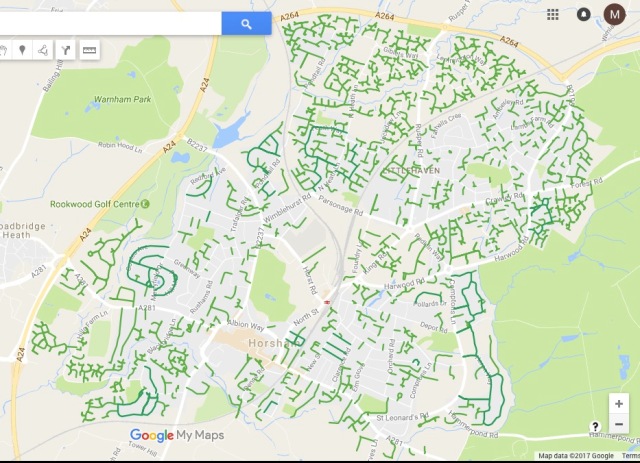
The village of Warnham is an interesting case study in this regard. Looking at a map of the area, we can see why there is a problem.

The village of Warnham, top centre

We can immediately see that the village (at the top centre of the map) lies in the middle of a path running east-west across the map – a path formed on the left by the A281, heading towards Guildford, and to the east, the A264, heading towards Crawley and Gatwick Airport.

Zooming in closer, I’ve drawn on the route that drivers are expected to take, following the main roads, if they were heading from Crawley towards Guildford.

I suspect the majority of drivers do follow this route – and in the opposite direction too. But it’s clearly a long way round, and there are a couple of tempting ‘direct’ routes, which cut off the long southward diversion, both of which run through or near Warnham, marked in red, below.

This problem has got, or will get, even worse, with the expansion of the village of Broadbridge Heath (now essentially a connected suburb of Horsham), to the south.

The old bypass of Broadbridge Heath is the yellow road; the new bypass has been built even further south, making the east-west route even longer.

That means fairly urgent action is required to alleviate, or remove entirely, the problem of drivers using some fairly narrow rural lanes as a shortcut alternative to main roads.

One of these interventions has taken place at the junction to the west, where Strood Lane (a narrow rural lane to Warnham) meets the A281. At this junction, people taking a short cut will want to turn right if they are heading west; conversely, they will want to turn left into this side road, if they are trying to drive east.

The junction in question, with the movements that need to be prevented

These movements have now in fact been banned, in conjunction with some minor engineering works that should support them. I went over to take a look at them a few days ago. I’m not entirely sure they will be effective.

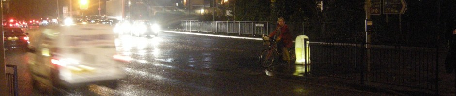
Here we are looking west – the A281 is the main road running across the picture, while I am standing on the minor lane, Strood Lane. As you can see right turns have been banned, but there isn’t an awful lot to stop people from ignoring the sign and just turning right, as this driver is doing, literally within 30 seconds of me arriving. The following two drivers did turn left, but I suspect people habituated to using this ‘rural lane’ route as their best option will not be deterred.

To the right of the photo, we can see an encouraging bit of engineering. The island simply wasn’t there before – it’s a big build out which I think will (almost) completely stop people turning left of the major road – the corner is far too tight to be taken at speed, and it will involve coming to a complete stop, and swinging out into the opposing lane on a fast, busy road. The best feature from my perspective is the cycle bypass – a good touch. There’s no need to ban cycle turns, and we have a nice bit of engineering to support that movement. Here’s the view of the junction looking south, from the A281 main road.

The minor oversight here is some ‘except cycles’ need to be added to both the banned turn signs.

The real question is how to properly discourage those right turns out of the side road. I suspect the engineering could have been far more severe, to truly force people into turning left out of Strood Lane.

In any case, if the turning ban is wholly effective, the ‘desired route’ will involve adding about 600m to people’s journeys, as they turn left onto the A281, circle around a roundabout, then resume their journey in their intended direction (and vice versa in the opposite direction).

Will that be enough to make this route unattractive? Again, I suspect not.

Another intervention appears to be taking place at the same time, on Byfleets Lane, one of the ‘red’ routes through this area (and in my view the more tempting of the two). On the section highlighted with a black border, this already narrow lane is being deliberately narrowed, and having a ‘hard’ margin added.

Apologies for the poor quality phone photo!

It’s not particularly clear from my poor photo, but this is about a four-inch high continuous metal ‘basket’, full of gravel, which will be difficult or impossible to drive over, hence restricting this lane to basically one vehicle’s width. Passing places are being installed at intervals. This will be quite effective, I think – it will reduce the temptation to charge through here, knowing that you will be forced to confront oncoming traffic, and may have to reverse to a passing place.

The slight irony is that these works are taking… three months, during which the lane is completely closed to motor traffic (see the orange barriers in the photo above). This suggests to me that a permanent closure halfway along – one which would still permit resident access – might be an option worth exploring.

Any thoughts welcome in the comments below!

Posted in Uncategorized | 16 Comments

A visit to a Highways England cycling and walking scheme – the A21 dualling

Last year I wrote about a section of the A23 – a Highways England-administered road – that had been widened (or ‘upgraded’) from a four lane to a six lane road, matching the motorway-like nature of the rest of this road as it runs south from Crawley (an extension of the M23 motorway) to the south coast at Brighton.

The subject of that post was principally the cycling and walking facilities that had been built as part of those construction works.

Part of the parallel walking and cycling route, constructed next to the widened A23

Prior to construction (between 2011 and 2014) this road was essentially a complete no-go area for walking and cycling, with no alternative but to cycle on a carriageway with a 70mph speed limit, carrying nearly 70,000 vehicles a day. There is now an alternative that is – for the most part – very good.

As I write this, a similar construction project is underway on another Highways England road, a section of the A21 between Tunbridge and Pembury, on the outskirts of Tunbridge Wells. This road is not as busy as the A23, carrying nearly 40,000 vehicles per day, it involves converting a single carriageway road into a dualled four lane road, rather than a six lane road.

But it is very reminiscent, in that it involves adding a lane in each direction, and in the fact  that parallel walking and cycling provision is being provided alongside this new ‘upgraded’ section of road. Again, like the A23, there was no cycling (or walking!) provision along the (single carriageway) pre-construction A21.

Definitely not a place for the fainthearted cycle user. Or anyone at all, really.

Last week Tunbridge Wells Bicycle User Group were invited to take a look at how construction of this parallel provision was coming along, with completion of the whole project due in September, and I was kindly invited along too.

The section of road being dualled, from a two-lane single carriageway, to four lanes

As you will see from the photographs that follow, the whole scheme is very much a work in progress. But the cycling and walking provision looks like it will be of a high standard.

Starting at the southern (Tunbridge Wells) end, the path runs northwards parallel to what will be a motor traffic slip road, joining the main A21.

The path here is something like 2.5-3m wide, which I think will be wide enough, especially given that, along this southern stretch, there will be parallel provision on the other side of the dual carriageway (but we didn’t get to see that, because of the nature of the construction work).

I suspect, going by what we saw, this will actually be the worst part of this path alongside the A21. The biggest issue here will be the proximity of the path to the carriageway; it certainly felt quite exposed walking along here, even with the lower traffic speeds on the A21 through the roadworks. There is definitely a need for some kind of barrier and (ideally) one that has some noise abatement function.

Further north, the path will be further way from the road.

Here we can see the new northbound carriageway, serving as a two-way A21 while construction takes places on the southbound carriageway, at the extreme right. We are walking on what is left of the old A21, which will form the foundations for the new path. The separation is much better here, although again it would be good to have something between the path and the road for more comfort.

Approximately one quarter of the way along the upgraded section of road, there is a an underbridge junction (helpfully marked as ‘underbridge’ on the map, above!), connecting up some rural lanes on the eastern side of the road. This bit of road also serves as the access point, off the A21, for the existing houses along the former road.

The road is (deliberately) bendy, to slow drivers down as they enter this new environment. The path will continue northwards alongside it, without interruption, although we were told it will be slightly narrower here, and closer to the road. The photograph above shows approximately where it will go, to the left of the road. There will (theoretically) be very little motor traffic here, and a lower speed too, so this proximity is not too much of a problem.

If you continue cycling north, you will then be using the former A21 road, which we walked along.

This will now serve as the access road for the handful of houses (four or so) along this old section of the A21 – you can see one of them to the left, in the photograph above. Although people who live here will now have slightly longer car journeys (this ‘service road’ will be a dead end to motor traffic, meaning they will have to drive back to the previous junction to join the A21) these residents will have a much better environment, living next to a very quiet lane instead of next to a fast, busy trunk road carrying 37,000 vehicles a day.

The same location (with matching telegraph pole) in 2014, courtesy of Streetview.

I shot a short video at this spot to give some idea of the change in nature of this road. You can still hear the A21, behind the bank, but it’s possible to talk quietly, and hear birdsong.

This service road continues northwards, running in parallel to the new road. For me the most impressive part of the new route is this cutting.

Again, we see motor traffic running in two directions on what will be the northbound carriageway. Meanwhile we are walking on what will become the dead-end service road, or cycle path (it will be gated at approximately this location, to stop drivers using it to continue northbound). Clearly, an enormous amount of ‘extra’ earth has been removed here to create a wide path, with good separation from the new A21.

Looking back southwards, as a construction vehicle follows us

Walking towards Tonbridge on what will be the walking and cycling route, fenced away from the new A21

The path will also be fenced off from the A21; we could see the fence under construction as we walked northwards.

In the distance here is the extent of the route we were able to walk; construction is still taking place. But even so we were able to get within a few hundred metres of the junction to the south of Tonbridge; this will form a very useful link between the two towns, which are only about four miles apart.

The real problem is going to be ensuring that Kent County Council (and the local borough councils) manage to build routes of this quality right into their town centres. This route will only connect up the outskirts of both towns; for people to cycle between them, they need the same high standard of facility along the length of their journey. If they have to battle along motor-traffic dominated roads just to reach this new path, then its potential will not even be remotely fulfilled.

Of course, in one sense it is relatively easy to build cycling infrastructure alongside this kind of road scheme. For a start it is something of a blank slate; the cycling infrastructure can simply be delivered with the project. And in addition there aren’t the kinds of issues that make building cycle routes in urban areas more problematic. To take just one example, there aren’t many junctions to deal with – the cycleway simply runs alongside the road. These are problems that will have to be overcome at a local level.

That said, it is very encouraging that a scheme that was developed many years ago is coming to fruition with what looks like a very useful piece of cycle provision embedded within it. Even within the last few years, Highways England have been moving forwards on the design of cycling infrastructure, so it is good to see something of this quality that dates from before those improvements. Highways England standards like IAN 195/16 – Cycle Traffic and the Strategic Road Network – represent one of the best avenues for ensuring that cycling is properly designed into our road network, at every level.

The challenge is going to be ensuring that provision of this quality is built into the existing Highways England (and regional equivalent) road network, not just into new schemes like this one, and even more importantly, ensuring it happens outside of the Highways England road network – where these new routes bump against the remit of local authorities who may have little or no experience, enthusiasm, or funding. If that doesn’t happen, then routes like this one will be isolated and underused – a waste of their potential, which would be a great pity.


My thanks to TWBUG, and to Alison from Balfour Beatty and Tom from Highways England for showing us around.

Posted in Uncategorized | 14 Comments

Inconsistency

Why is it that cycling is regarded as a serious potential risk in ways that motor traffic travelling at greater speeds (and with much greater momentum) is not?

Part of the explanation must lie in the fact that we have lived with motor traffic travelling at great speed around our urban areas for so long that is simply seen as ‘normal’. We don’t even notice it – it’s simply background wallpaper, a fact of life. Cars, lorries, vans and buses travel at 30mph along our roads and streets, and that’s just the way it is.

Meanwhile cycling – a mode of transport for which users rarely attain more than 20mph, and which weighs little more than the human being cycling – is something that has to be controlled; slowed down; enforced.

This isn’t helped by lazy urban design that all too often lumps cycling in with walking, placing it on pedestrian-specific infrastructure that is a recipe for conflict.

Cycling diverted onto a narrow, busy footway. What could possibly go wrong?

But I suspect there’s a little more going on behind the scenes here than simple bad design. As we shall see later in this post, even on high-quality cycling infrastructure that clearly separates cycling from walking, there is an expectation that cycling should be slowed down and controlled in ways that are simply absent on the adjacent road network, where motor traffic continues to thunder past at 30mph (or more).

Of course, the ‘controlling’ mentality has been most powerfully exhibited by the Royal Parks in the last week, who, having already installed a series of cobbled ridges in the western half of Hyde Park, are now proceeding to add another series to the (long-established) cycle path along the Broad Walk, which indirectly connects Hyde Park Corner with Marble Arch on the eastern side of the park. There will be 28 humps on this 1 km section of path.

The justification for doing this is (as always) people apparently cycling too fast. A speed of 32mph has been cited, but notably this is just one person, on one occasion. By contrast 93% of people surveyed by the Royal Parks are cycling below 20mph. A comment from a Royal Parks spokesman provides a little insight into the mentality of the organisation –

“If we have cyclists racing up and down a pathway at speed with pedestrians trying to cross that really doesn’t make for a pleasant visit, especially when we also have cases of pedestrians being shouted at for walking on pathways in the way of cyclists.”

What is deeply inconsistent about this attitude is that the roads running through Hyde Park continue to have 30mph limits, with very little to stop drivers from (entirely legally) travelling at this speed, and with little or no assistance to help pedestrians cross the road at key locations.

The crossing by the Serpentine Gallery on West Carriage Drive, helpfully labelled as a ‘Pedestrian Crossing Point’

The speed limit for drivers in the park is exactly the same as the single cycling outlier that has justified the installation of these cobbles, and  the evidence from other Royal Parks suggest that speeding is rife, with 54% of all drivers exceeding 30mph in the Outer Circle in Regents Park. (The Royal Parks interest in tackling ‘speeding’ in this particular park only seems to have materialised with the prospect of it being closed as a through route to motor traffic, with new cobbled ramps to slow cycling).

Equally there is absolutely no priority for pedestrians attempting to cross these roads, nor any apparent concern in the face of motorists ‘racing’ (not that this word would be used by the Royal Parks) at 30mph or above. Naturally, these are ‘roads’ where that kind of speed is completely fine, while cycling on the Broad Walk is a mere ‘path’ where 10mph is the desired speed.

The inconsistency is even more obvious when we consider that the Broad Walk itself isn’t a particularly direct or convenient route for anyone cycling along the eastern edge of the park – it involves a series of convoluted crossings at both ends to leave and rejoin the road network. The most direct route is of course Park Lane itself, a fast and unpleasant road that (incredibly enough) was built on the park in the early 1960s. So Park Lane is effectively a route through the park, a route where motor traffic travels at great speed and in large quantities, a route where people are killed and seriously injured in numbers, and where pedestrians have to wait minutes to cross the road.

When I cycle on the Broad Walk (for instance, to go to Westminster University) it is not out of choice, but because I have been pushed off Park Lane by the dangerous and inhospitable character of the road.

To punish me (and everyone else cycling on this route) is perverse, given it is a route of last resort. The best way to tackle this issue is not to make all our lives worse, but to provide clear, consistent space for cycling, be it in the park itself, or reclaimed from Park Lane – space that sensibly separates people cycling from people walking. (It’s notable that these latest proposals for the Broad Walk actually create new environments where walking and cycling are pushed into the same space, with no clarity for either type of user). The humps will not solve the ‘speeding’ problem (if it did, people on racing bikes would not cycle through the Arenberg Forest at close to 30mph), and they will create new problems.

The underlying issue here seems to be that pedestrian comfort and convenience only seems to be a matter of concern when cycling is involved.

A textbook example of this is the installation of zebra crossings on new cycling infrastructure in London, giving people on foot priority when they need to cross to bus stops. Now I think these are a good idea. They can now be installed without zig-zag markings and ‘Belisha Beacons’, making them a low-cost and low-hassle intervention that makes walking a bit easier and will barely inconvenience cycling at all, given the dynamics of these two modes.

But where is this degree of concern for ease of crossing on the rest of the road network? Central London boroughs are chock-full of junctions where people are sent on circuitous routes to safely cross the road, or where there are signals for motor traffic, but no separate green signal for pedestrians. Even bog-standard unsignalised junctions can be totally inhospitable for all but the most able-bodied pedestrians.

A sadly all-too-typical junction in Westminster. Once you have walked through the puddle in the dropped kerb you have to traverse, unaided, some 70 feet of tarmac, with motor traffic bearing down on you in this one-way system.

There doesn’t appear to be any particular concern about this neglect of pedestrian safety and comfort, widespread across the capital, yet crossing four metres of tarmac which only carries people cycling necessitates a zebra crossing. That’s fine, of course, and worthy, but it seems a curiously backward approach to leap into action when pedestrians have to deal with cycling, but to leave them totally helpless when they have to cross rivers of motor traffic travelling at 30mph.

https://twitter.com/citycyclists/status/811500612873502720


I walk a lot in London, and I would love to see a great deal more care and attention paid to pedestrian comfort and convenience. I am not encouraged, however, by a reluctance to install things like zebra crossings anywhere on the road network, except when it involves crossing cycleways. Nor am I encouraged by an enthusiasm to tackle ‘speeding’ by one particular mode, largely travelling at under 20mph, while roads administered by the same authority continue to have 30mph limits, with the majority of drivers exceeding that speed. Is it too much to ask for a rational and consistent approach on these kinds of issues?

Posted in London, Royal Parks, Safety, Sustainable Safety, Walking | 21 Comments

Will making driving routes longer persuade anyone to cycle?

There is a form of discussion in cycling campaigning circles on the types of policy required to enable cycling in Britain. This discussion ranges along a continuum from (at one end) a belief in what I would call ‘motoring-hostile’ measures, and at the other end, ‘cycling-focused’ measures.

Motoring-hostile measures include things like congestion charging, increasing parking charges, removing parking spaces, and so on; policies that, in and of themselves, don’t do anything to make cycling more attractive, but (it is argued) may force people to consider other modes of transport, including cycling. Meanwhile cycling-focused measures involve ensuring that cycling is a safe and attractive mode of transport, from door-to-door.

I don’t think it’s any great secret that I tend to lie towards the ‘cycling-focused measures’ end of the continuum. I don’t think making driving more difficult will increase cycling to any great extent, principally because –

  • it doesn’t do anything to address the main barrier to cycling; unpleasant, unsafe and subjectively hostile cycling environments.
  • driving is already a difficult, frustrating and unattractive mode of transport in Britain, particularly in urban areas.

In this post I’m going to look at just one aspect of this debate; namely, whether making journeys for drivers more inconvenient (allegedly, like those journeys might be in the Netherlands) would have any effect on cycling levels.

Back in January I plotted a Dutch network onto a British town (and wrote a blog post about it!). To my slight surprise, it turned out that a very large proportion of the road network of Horsham is composed of access-only roads – roads that are cul-de-sacs for motor traffic, or that make no sense to drive on unless you are a resident, or visiting a property on that street.

All the roads in green are cul-de-sacs, or genuine access roads

All the roads in light or dark green are cul-de-sacs, or genuine access roads

Why is this important? Well, it means that the town of Horsham already has what I would describe as a Dutch-style motoring network.

The way drivers will move about the town is very similar to the way they would move about an equivalent Dutch town. They will not be using residential or access roads to make journeys, because it is impossible to use them (they are dead ends!) or because it makes no sense to use them (there is a ‘main road’ route that is quicker, or less circuitous). Their journeys will not be direct. Here’s just one example – driving from a residential street, to join a main road to the north.

screen-shot-2017-03-02-at-11-56-44

A substantial part of the town has this kind of road network. Like many other towns across Britain, it has expanded rapidly since the mid-twentieth century, and is consequently largely composed of a dendritic highway pattern, designed to create safe, quiet streets in the age of the motor car.

Exactly the same kind of road network for drivers that you will find in the Netherlands.

Residential street pattern in Horsham (left) versus residential street pattern in Assen, NL (right)

Residential street pattern in Horsham (left) versus residential street pattern in Assen, NL (right)

Driving in Horsham will involve the similar kinds of journey patterns (and journey lengths) to equivalent trips in Assen.

Now, the cycling mode share in Horsham is, at best, something like 2% of all trips (cycle to work share in the 2011 census was 1.6%), while in Assen it is around 40%. So, given this intrinsic similarity in driving patterns, how do we account for the large difference in cycling mode share between the two settlements?

There are no stunning geographical differences between Horsham and an equivalent Dutch town; it is flat and reasonably compact – no barriers to cycling in this regard. So if driving in Horsham is just as circuitous, arduous and difficult as it is in Assen (if not more so), then what is the principle reason for the difference?

My view is that it has to be that cycling is too difficult and unpleasant, rather than driving being too easy.

  • Principally, we have a hostile (main) road network that the vast majority of the people in the town will not dare to go anywhere near on a bike.
  • Secondarily, we have a ‘permeability’ problem. In many places, what could be short trips by bike are converted into very long ones (just as long as the circuitous driving trip) because of an absence of short connections between roads and streets.
A typical main road in Horsham - a substantial barrier to cycling

A typical main road in Horsham – a substantial barrier to cycling

Neither of these barriers will be tackled by making driving more circuitous; indeed, it is hard to see how driving could be made substantially more difficult in this regard, given that the town is already largely composed of a dendritic highway pattern for drivers.

The obvious conclusion – if we are interested in increasing cycling levels – is that sensible policy should focus on creating safe and attractive conditions for cycling, and on opening up (or improving) connections for cycling between currently different parts of the town, rather than expecting drivers to be prised out of their cars by making their routes longer – we’ve already done this in Horsham (albeit through historical accident) and we have negligible cycling levels.

Posted in Uncategorized | 19 Comments

Positivity

Andrew Jones MP – the Parliamentary Under Secretary of State for Transport, with specific responsibility for cycling – spoke (and answered questions) at an All Party Parliamentary Cycling Group meeting on Tuesday last week. A video of that meeting was recorded by the APPCG – you can see it here.

The full video is 36 minutes long, but at about the 4:45 mark, Jones has this to say –

One thing I think we do need to do, and that’s change some of the music around the whole sector. At the moment it is I think often quite negative. And I think we need to change that. In fact I am slightly puzzled by people who say that cycling is such fun always seem to have such a negative social profile. Social media sometimes lends itself to that. But we won’t encourage more people to making these choices unless it is a positive choice. And it is a positive choice. It is positive because it is fun. It is good for the environment. It is good for you. There aren’t that many things that are good for you and that are fun, but cycling is one of those things. It also helps tackle congestion within our streets. So the upsides of cycling and walking are just fantastic. So I want this to be a very positive moment. I want the Cycling and Walking Strategy publication to be a bit of a landmark, where we start to see more support going in, but we start to talk about things in a more positive way, and try to encourage people to make that trial if they haven’t been cycling for a while, or to make that switch to a more permanent choice.

These are curious comments. The implication is that if people who have enthusiasm about cycling as a mode of transport somehow fail to be ‘positive’, we won’t ‘encourage more people’ to cycle.

Now I wouldn’t be a cycle campaigner if I didn’t think cycling was a fantastic mode of transport – I am positive about it, in that sense. It’s a straightforward, cheap, fun, fast, and convenient way of getting about, almost certainly the fastest way of getting about in urban areas. It is an enabling mode of transport that will make all our lives better.

This

This is what I want to see in Britain.

But that does not mean my enthusiasm will extend to cycling in any conditions; nor does it mean my enthusiasm has to extend to any initiative, from government or otherwise, that alleges to be ‘for’ cycling. Nor does my enthusiasm mean that I won’t be critical about policies that will have negligible effect, or will be useless, or actively harmful.

Equally, I resent the implication that being critical (or ‘negative’) will in some way keep anyone from cycling. There is an overwhelming body of evidence that the main barrier to cycling uptake in Britain is an absence of safe, attractive cycling environments; people do not want to cycle on motor-traffic dominated roads and streets. No amount of sunny ‘positivity’ is going to change this; likewise, no realism about the fact poor cycling environments are a serious barrier to cycling is going to stop people from cycling.

Positivity or negativity from cycle campaigners will have no effect on whether people choose to cycle in these kinds of environments

Positivity or negativity from cycle campaigners will have no effect on whether people choose to cycle in these kinds of environments

I am more than happy to be positive about policy that will genuinely enable cycling; to be positive about policy that does lead to changes to the way our roads and streets are designed, to allow anyone to cycle. But the blunt reality is that government has a consistent, long track record of failure in this regard, particularly when it comes to leading on the matter of design.

In this regard it is particularly noteworthy that, in the very same APPCG meeting, the Minister described the frankly woeful LTN 2/08 Cycle Infrastructure Design as ‘fit for purpose’. It is nothing of the kind –  instead it is out of date, filled with half-hearted (and often mistaken) advice, a document of low horizons and lazy compromises, one that has very little to offer in the way of inclusive design.

In the face of such complacency, negativity is precisely the right response.

Posted in Uncategorized | 13 Comments

Some basic rules for journalists and broadcasters covering cycling

While there are plenty of honourable exceptions, I think it is fair to say that presenters, journalists and broadcasters in the UK do not do a particularly good job when it comes to covering cycling as a mode of transport.

Some of this might well be down to outright malice, but a large proportion of poor journalism and broadcasting is simply down to laziness and an unwillingness, or inability, to address these issues from someone else’s perspective, or even to think slightly differently.

With that in mind I’ve drawn up a fairly simple list of rules and advice for covering cycling in a sensible, constructive and fair way. There may be others – let me know in the comments – but I think if journalists, broadcasters and presenters are following these rules it’s more than likely they will be doing a good job.


1) Do not use them/they language

By this I mean referring to people who are using a mode of transport as ‘them’ or ‘they’, and everyone else as ‘us’. One example (and this from a BBC radio journalist) –

screen-shot-2017-02-08-at-08-05-46

Who is ‘they’?

For starters, this kind of language is incoherent. It makes no sense to divide human beings up by mode of transport when we will all use different modes of transport on a daily basis.

Someone who is cycling at one moment will of course have been walking the same day, and will drive or use public transport. Someone who is on a train or a bus may well have cycled to the station, or to the bus stop. Human beings – all of them – are multi-modal. Referring to ‘cyclists’ in this way is exactly equivalent to asking what it is about ‘trainists’ or ‘busists’ that annoys your audience. If you think that would be deeply silly, then you should reflect on why you think it is acceptable to do so about another mode of transport. Your audience will not divide up neatly into ‘trainists’ and everyone else; nor will it divide up neatly into ‘cyclists’ and everyone else.

But much worse than this incoherence, using this kind of language is divisive and unpleasant. It contains the starting assumption that people cycling aren’t ‘us’; that your audience have some kind of grievance against ‘them’, and indeed that your audience isn’t composed of ‘them’. There is no ‘them’.

screen-shot-2017-02-08-at-12-42-06

‘Them’?


2) Do not engage in antagonism; focus on solutions to problems

This kind of antagonistic ‘journalism’ takes many forms when it comes to cycling. It might be of the form above – how do ‘they’ annoy ‘us’. This could be cycling on pavements, or cycling in ‘the middle of the road’, or breaking rules in general. Alternatively it might take the form of a ‘war on the roads’ or ‘who is to blame’ narrative.

As above, this is divisive and unpleasant, but perhaps even worse it is not constructive. Once you’ve written your piece about how cyclists annoy everyone else, or about how there’s ‘a war out there’, or once you’ve decided ‘who is to blame’, everything will carry on as before. Nothing has changed; the same problems still exist, and you’ve done nothing to solve them. In fact, you’ve probably made them even worse, because of the antagonistic way you have framed the debate.

Some examples –

  • Instead of focusing on whether ‘lorry drivers’ or ‘cyclists’ are at fault when deaths or serious injuries occur, take a broader view and examine structural solutions (like the way our roads and streets are designed) that will prevent these deaths and injuries from occurring in the first place.
  • Instead of simply echoing complaints and annoyances like pavement cycling, or the way people are cycling – again, try to examine what is giving rise to the conflict, and what might solve it.

In other words, focus on long-term solutions to problems, rather than the usual merry-go-round of antagonism.

An obvious way to prevent pavement cycling is to create safe, attractive conditions, separate from it

An obvious way to prevent pavement cycling is to create safe, attractive conditions, separate from it


3) Empathise rather than demonise

This flows naturally from the previous two points of advice. Instead of focusing on the behaviour of ‘them’, become one of ‘them’ yourself to understand why people are behaving in a certain way. This might not even involve actually cycling; it merely involves trying to imagine what you would do if you were cycling in a specific context, or if someone you care about was trying to cycle.

What would you do if you had to cycle along this road? How would you react if a friend of yours was cycling here?

What would you do if you had to cycle along a road like this? How would you react if a friend of yours was cycling here? Put yourself in their shoes and examine how you would behave.


4) Don’t generalise from anecdotes

Seeing someone on a bike doing something a bit silly is not a good basis for an entire article about people cycling in general. At all. People do silly things all the time, in all walks of life, using different modes of transport. What you saw was an individual being stupid, not something that was indicative of ‘cyclists” (whoever they are – see point 1) behaviour.


5) Focus on sources of danger, and how that danger should objectively be reduced

Not all road users are equivalent. They do not pose equal amounts of danger to others; consequently they do not share equal responsibility.

The young children on the left not equally responsible to the HGV drivers on the right

The young children on the left not equally responsible to the HGV drivers on the right

That doesn’t mean anyone cycling has no responsibility at all – rather, that the degree of risk posed by different forms of transport should be assessed objectively. This should also mean distinguishing between the degree of risk someone is posing to other people versus the risk someone might be posing to themselves.

If we start looking at risk objectively, then we will come up with constructive, long-term solutions to danger on our roads and streets. (See Point 2). If, for instance, it is allegedly ‘too dangerous’ to cycle around in ordinary clothes (or indeed to walk around in ordinary clothes), then start asking why that should be the case, rather than focusing on the people wearing ordinary clothes and how they are being ‘irresponsible’.


6) Finally, you don’t always need to provide ‘balance’

Not every article or piece about cycling has to present an opposing view. You just need to let the facts speak for themselves; you certainly don’t need to give airtime to an idiot arguing black is white just to ‘even things up’ in the face of those facts.


Posted in Uncategorized | 54 Comments

Cycle Traffic and the Strategic Road Network – Junctions (2)

This post is the last in a series looking at the new Highways England standard on designing for cycling, Cycle Traffic and the Strategic Road Network, or IAN 195/16. The previous three posts can be found herehere and here.

As mentioned in my previous post, designing for cycling at junctions is important, and consequently junctions (rightly) occupy around half the length of the Cycle Traffic and the Strategic Road Network. I’ve split my coverage of junctions into two posts; this second post will look at roundabouts and ‘grade separation’, or in layman’s terms, ‘putting cycling at a different level from the road network’. That means bridges or underpasses – or a hybrid of both.

Given that this is a Highways England document, grade separation will naturally be particularly important, due to the type of most of the roads covered by the Highways England network – fast, busy roads where grade separation is likely to be the most appropriate option. As IAN 195/16 itself states –

Grade separation of cycle traffic from motor traffic is the preferred solution for the crossing of all high speed road links and junctions.

Referring back to Table 2.4.2 in the document (covered in the previous post) we can see that grade separation is the only option for crossing roads with a speed limit of 60mph or higher.

screen-shot-2017-02-06-at-15-28-42

It is also the ‘preferred’ type of crossings of 40mph and 50mph lanes of traffic with over 10,000 vehicles per day (or crossing two or more lanes with >6,000 vehicles per day), and for 30mph roads (or single lanes) carrying more than 8,000 vehicles per day. As mentioned in the previous post, designers ‘shall’ use the ‘preferred’ type of crossing unless other options make more sense in terms of route continuity. So clearly grade separation is important (and required) in situations with fast and/or heavy flows of motor traffic.

Naturally the two types of grade separated crossings are underpasses and bridges, although this document describes them respectively as ‘underbridges’ and ‘overbridges’, which I think is an important reframing. Good underpasses will resemble bridges, in that the cycle traffic is passing under a bridge carrying the motor traffic above it.

Grade separation in the form of an underbridge in the Dutch city of Assen.

Grade separation in the form of an underbridge in the Dutch city of Assen.

As in the photograph above, these ‘underbridges’ are clearly a much more attractive proposition than the kind of subterranean tunnels that ‘underpasses’ usually resemble in Britain. Explicitly framing this kind of grade separation as a ‘bridge’ is therefore very helpful. The photograph of an ‘underpass’ included in IAN 195/16 makes this obvious too.

screen-shot-2017-02-06-at-15-40-47

The minimum width for cycle traffic through this kind of underbridge is set at 3m, with only a suggestion that designers should ‘consider’ increasing this dimension to increase natural light. I don’t think that’s good enough; it allows ‘boxy’ underpasses of this type –

A relatively new Highways England underpass, under the A23 near Handcross in West Sussex.

A relatively new Highways England underpass, under the A23 near Handcross in West Sussex.

These are much less attractive than the Dutch stipulation that ‘walls should recede towards the top’. Here’s a path of equivalent width, but with sloping walls, in the Netherlands –

screen-shot-2017-02-06-at-16-27-39Much more open – so it would be good to have some stipulations about tunnel dimensions, beyond the 3m width recommendation.

We have similar width stipulations for overbridges – at least 3m, with 0.5m margin clearance at each side. There are useful recommendations on gradients; ramps approaching or departing grade separation should meet the design requirements set out earlier in IAN 195/16 –

screen-shot-2017-02-06-at-16-55-19

It is recommended that the steepest part of a ramp (if it is unavoidable) should be located at the start of the ramp, where people are likely to be carrying most speed. Given that this has been taken into account, it is slightly disappointing that IAN 195/16 does not have anything to say on the matter of overbridges versus underbridges in general.

Underbridges should generally be preferred, mainly because the speed that a person cycling carries into them (on the downslope) can be used on the upslope; this isn’t the case with overbridges. Underbridges should also be preferred because they require less slope in general; they only need to accommodate the height of a human being, rather than the height of the large vehicles a bridge has to pass over. This is missing from IAN 195/16.

At the rear of the document there are extensive ‘grade separation’ diagrams, showing the appropriate way to separate cycling and motoring at junctions, particularly those with slip roads, which present a major safety hazard. Here’s just one example, showing cycle traffic (the dark line) routed under the slip roads, and under the roundabout.

screen-shot-2017-02-06-at-17-04-47

This kind of design removes any interaction with fast motor traffic altogether, something IAN 195/16 requires for 60mph+ speeds and for heavier flows of motor traffic. So we should expect to see this form of grade separation at new junctions being built by Highways England (but unfortunately not retrofitted to old junctions, as yet).

The one final ‘junction’ element covered by IAN 195/16 is roundabouts. Britain has a long history of failing to design for cycling altogether at roundabouts, and we still haven’t really managed to do so in the last few years, despite increasing design attention being paid to cycling. So the advice (and indeed requirements!) contained within IAN 195/16 is welcome, even if (unfortunately) there is very little UK good practice to draw upon.

Happily, on-carriageway perimeter cycle lanes on roundabouts are explicitly ruled out –

On-carriageway cycle lanes shall not be provided on the perimeter of the circulatory carriageway, as they encourage cyclists to take up a nearside position where they are vulnerable to being hit by vehicles exiting the roundabout.

The only options are a ‘compact’ (i.e. a continental-style) roundabout with no lanes or markings, combining cycling with motor traffic, or a ‘separate cycle track’ around the perimeter of either ‘compact’ or ‘normal’ roundabouts, with a recommendation that the latter is preferable ‘because most cyclists will prefer off-carriageway provision as they will perceive it to be safer and more comfortable.’ Indeed, off-carriageway cycle tracks ‘shall be provided’ once the total throughput on a compact roundabout exceeds 8,000 vehicles per day.

There are all the elements in place in IAN 195/16 for Dutch-equivalent design of cycleways around roundabouts – how wide cycleways should be; when (and when they shouldn’t) have priority over motor traffic when crossing the arms of the roundabout. Unfortunately all this good advice (and requirements), much of it covered in previous posts, does not appear in the form of a useful diagram. There aren’t any illustrations on how to design for cycling at priority roundabouts (i.e. roundabouts that are not signal-controlled), which is a pity.

This isn’t too much of a problem for Highways England roads, where I doubt these kinds of designs would be used, but it is a design gap that needs filling, and this document could have provided design requirements and advice that local authorities could have copied, or drawn from.

As it is, we have some diagrams on how to design for cycling at signal-controlled roundabouts, including complete signal-separation, the use of holding exit motor traffic (the approach used at the ‘Dutch’ roundabout in Wandsworth) and the ‘cycle gate’ ASL (or ‘always stop’ ASL), favoured by Transport for London at a number of locations. IAN 195/16 has some useful suggestions on the appropriateness of each of these, in turn – pointing out, in particular, that the ‘cycle gate’ ASL

introduces a time penalty for cycle traffic and will therefore be less suitable for cycle traffic movements that pass through a number of signalised nodes

… but it is unfortunately hampered by the UK not doing any of this particularly well, anywhere. The only concrete example it can draw upon is the Wandsworth ‘Dutch’ roundabout, which is far from ideal.

And that’s pretty much it for IAN 195/16! I think this has been a fairly comprehensive overview. However, there may have been some elements or aspects of it that I have missed, and (in particular) I think there is some scope for examining how useful it might actually be in practice, in terms of improving the way England (and the UK) designs for cycling in general. So there is potential for a ‘summary’ post covering these kinds of issues, including those raised in the comments to all four posts.

Posted in Uncategorized | 12 Comments

Cycle Traffic and the Strategic Road Network – Junctions (1)

This post is part of a series looking at new Highways England standard on designing for cycling, Cycle Traffic and the Strategic Road Network, or IAN 195/16. The previous two posts can be found here and here.

This particular post will look at how junctions are covered in IAN 195/16. Junctions are important, and this is clearly recognised in the document – dealing with them accounts for around half of its 68 pages. For that reason I’m going to break up my assessment into two posts.

IAN 195/16 starts by giving an overview of the various design options that can be employed to minimise or eliminate the ‘significant conflict’ that can arise between motor traffic and cycling at junctions, ranging from grade separation and ‘unravelling’ (i.e. putting cycling onto completely different routes), right down to slowing motor traffic when turning on ‘low volume roads’. In other words, the full spectrum of approaches employed on Dutch cycle networks.

On page 32 we have this large, clear table of what kind of junction treatment is appropriate (and indeed required) for cycle traffic, given the speed and volume of motor traffic.

Suitable Types of Cycle Crossing, IAN 195/16

Some things immediately leap out from this table. If motor traffic is travelling at 60mph or above, any crossings of these roads have to be grade separated – i.e. in an underpass, or by means of a bridge.

The table also (importantly) stipulates the maximum number of lanes that should be crossed in one movement, again according to speed and volume. So for instance, above 6,000 motor vehicles per day on a 40-50mph road requires a refuge, allowing one lane to be crossed at a time.

The design options are split into ‘preferred’ and ‘other possible’ crossing types, with this stipulation –

Designers shall use the “preferred” option in Table 2.4.2 unless there is a need to provide continuity with other existing cycle route provision and where agreed with Highways England.

The word ‘shall’ being a requirement; ‘preferred’ options have to be used unless continuity is necessary.

The document then looks at the various types of crossing in turn. We’ll start with ‘signalised’ crossings. Unfortunately I immediately find something to disagree with!

Cycle traffic may be controlled by low and high level cycle signals at the cycle stop line. Secondary high level cycle signals should be considered where there is a risk for approaching cyclists of poor visibility of low level signals, or obscuration, due to layout constraints or high levels of demand.

I think this gets the importance of high and low level signals the wrong way round. Low level signals should not be the ‘primary’ signal, with high level signals an optional ‘secondary’ signal, something merely to be ‘considered.

Low level signals are essentially provided for convenience – for people waiting at lights to avoid having to look upwards. They should not be viewed as the ‘primary’ signal for reasons given in the paragraph – they can be obscured easily (by people waiting, for instance), and are smaller than high-level signals. Low-level signals are much harder to see on the approach to a junction, even if they are not obscured.

Low-level signals and high-level signals, both showing red. Which one is easier to see from a distance?

Low-level signals and high-level signals, both showing red. Which one is easier to see from a distance?

A low-level signal in isolation is not a good idea; it means people approaching the junction do not have an indication of whether they will have to stop until they are only a short distance from the junction – or no indication at all, if the low-level signal is obscured. For that reason the high-level signal should always be employed, with the low-level signal as the ‘optional’ extra. IAN 195/16 gets this the wrong way round.

IAN 195/16 does however suggest the use of cycle detectors on approaches, and synchronising lights so people cycling get smooth journeys through junctions, which are obviously sensible recommendations.

It also makes clear that the ‘default’ design option for cycling should be a single-stage crossing, ‘without the need for cycle traffic to wait on islands in the middle of signal controlled junctions’ – mainly because cycle traffic is faster than pedestrian traffic, and can cross junctions relatively quickly. There are clear stipulations for signal timings to ensure that slower-moving cyclists can safely clear a crossing, depending on its length and gradient. For instance, a 36m crossing of six lanes (2 x 3) on an uphill gradient requires 16 seconds, from a standing start.

IAN 195/16 is clear that ‘Toucan crossings’ (essentially, cycling bodged onto a pedestrian crossing) are inferior –

Toucan crossings are less comfortable for both pedestrians and cyclists than separate crossing facilities. They shall only be used where it is necessary to share the same space at the facility, for example where there is a shared path leading to the crossing or where there are complex off-carriageway pedestrian and cycle movements that are best accommodated in a shared use area.

… although I’m not quite sure this is clear enough to avoid them still being used as a bit of a lazy bodge, in combination with shared use.

Staggered crossings are essentially ruled out, unless they can accommodate the ‘cycle design vehicle’ (1.2m x 2.8m) on an appropriately-designed two-way cycle track.

The dimensions of refuges (which are very important for ‘priority’ types of crossing) are stipulated; they must be at least 3m long in the direction of travel for cycle traffic. Here’s an example of a 3m refuge at a Dutch roundabout on a rural main road.

screen-shot-2017-01-31-at-12-44-12

Refuges should be able to comfortably accommodate cycles of all types in this kind of situation.

We then come to a longer section on priority junctions in general, and how cycle movements should be handled at these kinds of junctions.

‘On carriageway’ cycle provision – i.e. painted lanes, or simple ‘combined traffic’ is, as per earlier requirements in IAN 195/16, only appropriate on roads with 30mph limits and with traffic flows under 5,000 vehicles per day. Roads with traffic speeds of 40mph or over require cycle tracks. Given these constraints, there isn’t a great deal to say here, beyond ensuring that junction geometry is tight to ensure lower motor traffic speeds at the conflict point – although I’m not sure the reference to a minimum 10m corner radii in rural areas (Section 7.17 in TD 42/95) is appropriate.

IAN 195/16 does also stipulate that if slip roads are present under these speed/flow conditions, cycle traffic ‘shall be accommodated using off-carriageway facilities’, regardless of the lower speed limits and motor traffic volumes.

The aforementioned corner radii recommendation also means that IAN 195/16 is stipulating that any ‘physical separation’ of cycle lanes on these kinds of roads has to end a minimum of 20m from the junction, which is poor. It essentially leaves anyone cycling on these lanes feeling dreadfully exposed on the approach to, and at, the point of conflict, and won’t do anything to slow turning speeds. Just like these bad examples on the Leeds-Bradford ‘superhighway’, below.

Screen Shot 2016-08-11 at 02.35.20

Where ‘off-carriageway’ provision is employed (i.e. cycle tracks), IAN 195/16 gives us a choice between ‘bent out’ and ‘bent in’ crossings of side roads.

‘Bent in’ crossings are defined as –

‘bent in’ towards the major road so that cycle traffic crosses the mouth of the minor arm as a mandatory cycle lane

I have to say I have never seen this kind of design employed anywhere in the Netherlands – it essentially involves a cycleway, at distance from the road, moving onto it and becoming a cycle lane at the junction, as per the diagram in IAN 195/16.

screen-shot-2017-01-31-at-13-03-29

Perhaps this kind of design has been used somewhere in the Netherlands, but it must be very rare and I think it is inferior to maintaining a cycleway across the junction, even if that cycleway is only a short distance from the give way line. Maintaining a cycle with visual continuity affords more comfort and safety than reintroducing people onto the road, on a painted lane.

With the caveat that this is a two-way track, this kind of design is clearly more appropriate than a cycle lane crossing the side road on the carriageway

With the caveat that this is a two-way track, this kind of design is clearly more appropriate than a cycle lane emerging onto the carriageway to cross the side road

The ‘bent out’ type of crossing recommended by IAN 195/16 is obviously far more familiar, and ubiquitous in the Netherlands, employed either with simple painted markings, as in the example below (which is a non-priority crossing for cycle traffic) –

screen-shot-2017-01-31-at-13-13-53

… or with more ‘visual reinforcement’ – coloured asphalt continuity, and a hump, and give-way markings.

screen-shot-2017-01-31-at-13-15-38

And it’s here that we hit a bit of a snag with IAN 195/16. It stipulates that this ‘priority’ form of crossing is only appropriate on roads with a 30mph limit, or below. (And the same applies for the less preferable ‘bent-in’ crossing).

That means that any main road with a 40mph limit or higher cannot have any priority crossings for cycle traffic along it. It will involve giving way at any side road, regardless of how well that side road has been designed, like the example above. All crossings in this context have to be ‘non priority’.

This might not be a particularly onerous problem for the kinds of roads that are – at present – covered by IAN 195/16. That is to say, trunk roads that mostly go through rural areas, with few side roads, and where having to yield isn’t too much of a problem. In my experience cycling along 80kph roads in rural areas in the Netherlands, non-priority crossings are reasonably common alongside priority ones, depending on context, and they are not noticeably frustrating. The photograph above of a non-priority crossings is fairly typical.

However I think this stipulation is too rigorous – simply applying a blanket ‘non-priority’ rule above 30mph quite obviously rules out priority anywhere alongside faster main roads, even where it can be designed for safely, or where it simply makes sense.

Another photograph of a priority crossing alongside an 80kph road, so new it is still under construction!

Another photograph of a priority crossing, this one next to a section of 60kph (40mph) road, so new it is still under construction! Note this crossing has nothing more than simple give-way markings for motor traffic. Finished crossing here

So overall, although there are good design recommendations (and requirements) in this part of IAN 195/16, I think it is one of the weaker sections of the document. Some of the design ideas (the ‘bent out’ crossing; the removal of separation 20m before junctions) are not really good enough, while other requirements are too severe. There is definitely room for improvement here.

We’ll wrap up this look at IAN 195/16 in the next post, with a look at other ways of dealing with cycle traffic at junctions!

Posted in Uncategorized | 20 Comments

Cycle Traffic and the Strategic Road Network – Cycleway design

Earlier this week I blogged about a new Highways England standardCycle Traffic and the Strategic Road Network, or IAN 195/16. This is a 68 page document with plenty of detail, and for convenience I’m breaking it up into chunks.

That first post looked at the basics of ‘Cycle Traffic’ covered by IAN 195/16 – this post will look at what the document has to say about how cycleways should be designed, in particular, and what form they should take, according to context.

One of the first things we encounter in this section is a table of desirable and absolute minimum widths, according to the expected flow at peak times, and the nature of the cycleway.

screen-shot-2017-01-24-at-22-23-29

As explained in the previous post, ‘absolute minimums’ can only be used where there are existing physical constraints. But even these ‘absolute minimums’ are reasonable generous – a two-way cycleway with a peak hour flow of over 150 cycles per hour (two-way) has to be at least 3.5m wide, and it can be that narrow for only 100m at a time. This is roughly equivalent to sections of the new superhighways in London, so a good standard, even for an absolute minimum.

The 4m wide cycleway on Blackfriars Bridge

The 4m wide cycleway on Blackfriars Bridge

Explicitly, these values also do not include the additional width required ‘to maintain effective width’ – i.e. the usable width of a cycleway with kerbs or vertical features beside it.

screen-shot-2017-01-24-at-22-32-51

From this table, a cycleway with vertical kerbs requires an additional 20cm of width, while one with a feature like a railing or a parapet requires an additional 50cm of width. All very sensible stuff.

We also have guidance on how to improve social safety, including lighting, making sure the route is overlooked by passing people and traffic, ensuring good sight lines, and low vegetation. This is also refreshing –

Sign posts and lighting columns shall not be placed within the width of a cycle track, and shall have a minimum clearance of 500mm between the edge of the cycle facility and any parts of the sign or lighting assembly that are less than 2.3m in height.

The word ‘shall’ here is a requirement, not a recommendation.

IAN 195/16 recommends (throughout) separating pedestrians and cycle traffic, and is explicit that the difference between the footways and cycleways should be clear, either with verge separation, or with height separation. Forgiving ‘splayed’ kerbs are recommended –

Using splayed kerbs along the edges increases the effective width of the cycle track and helps to prevent collisions by reducing the risk of pedals striking the kerb.

Table 2.3.2 in the document is too large to include here, but is a very good summary of the potential , respectively, of using one-way or two-way cycleways, and the appropriate contexts for their use. Again, it’s all sensible stuff – for instance –

If cycle users persist in using one-way tracks the wrong way, this suggests that the facility may need to be made two-way.

This kind of behaviour suggests an obvious desire line, with people cycling not wishing to cross a road to cycle a short distance in the ‘wrong’ direction. Similarly –

In situations where there are one-way cycle tracks on links approaching junctions, designers should provide two-way cycle tracks within the junction if they offer a safer more direct way to negotiate the junction.

We also have an important table setting out the minimum requirements for horizontally separating a cycleway from a road, according to the speed of motor traffic on that road.

screen-shot-2017-01-24-at-23-41-36

This table means that ‘stepped’ cycleways (or ‘hybrid’ cycle tracks) are only appropriate on roads with 30mph speed limits, or less.

While I agree with the height stipulation for stepped tracks (50mm above the road) I do not agree with this –

Stepped tracks shall return to the carriageway and become initially mandatory lanes before changing to Diagram 1010 (reference TSRGD) [15]2 markings through junctions.

My view is that stepped tracks should continue across side road junctions, unchanged – that visual priority is lost if the track ‘returns to the carriageway’ and becomes a mere painted lane (the dashed ‘1010’ marking), and indeed any advantage of having the cycleway raised above the road (which would slow drivers) is lost too. Old Shoreham Road is used as a photographic reference in IAN 195/16, yet the stepped tracks at side roads here (generally) continue unchanged across side roads.

screen-shot-2017-01-24-at-23-57-54

This ‘continuous’ kind of arrangement also ensures the cycleway remains level, rather than bumping up and down at each side road, as would be the case with the IAN 195/16 stipulation.

There follows the familiar guidance on cycle lanes, which includes some advice on how to apply ‘light segregation’ features. I mentioned in the previous post that I think 30mph limits with 5000 vehicles per day is too weak for mere painted lanes, so applying light segregation in that context would remedy that weakness. IAN 195/16 mentions wands, ‘low height separators’ (presumably things like armadillos), and short sections of raised kerb – but doesn’t give any view or advice on which is superior or appropriate, according to context. My own view is that armadillos are pretty much a waste of time; the raised sections of kerbs or wands are much more effective (and indeed they appear to be being used by TfL for the diversion of CS3) and it would be good to see them being given greater weight here.

In this section we also have advice on dealing with cycling alongside buses, and bus lanes. It’s not explicitly stated, but the impression given is that designing for cycling in bus lanes should be avoided as much as possible. Where ‘sharing’ has to take place, it must be at 30mph or under, and the bus lane must be ‘no narrower than 4.5m wide’, ruling out sharing in conventional bus lanes in standard lane widths. I think this is still weak, however – IAN 195/16 would (for instance) still allow cycling in 4.5m, 30mph bus lanes with up to 5,000 buses a day (two-way flow). That’s not an environment I can envisage my other half cycling in.

The bus stop bypass recommendations are good, however, with an explicit requirement that bus stop islands are used –

The bus stop shall be placed so that users on the bus do not directly step down onto a cycle track when leaving the bus.

That is to say – ruling out the ‘Copenhagen’ style of bus stop where bus passengers step straight onto the cycleway from the bus, familiar from Royal College Street in Camden.

The final noteworthy element in this section is a similar, explicit rejection of all kinds of ‘access control’ on cycleways, except for bollards.

In most cases, a single bollard (reference Figure 2.3.8) is sufficient to prevent motor traffic from entering routes for cycle traffic. The gap between posts and other physical constraints shall be no less than 1.5m so as to prevent access by cars while retaining access by cycles. Bollards shall be aligned in such a way that enables a cycle design vehicle to approach them in a straight alignment.

A frame and K Frame type barriers, often used to prevent motorcycle access, shall not be used on cycle routes because they cannot be negotiated by the cycle design vehicle.

… the ‘cycle design vehicle’ being an (abstract) vehicle of fixed dimensions that, if designed for, would allow access by all types of cycles, including hand cycles, cargo bikes, adapted cycles, tandems, and so on.

So, all in all, there is more excellent stuff here, although it has to be said it is a little weak in places, and contains at least one requirement I don’t agree with. The next section to be covered is junctions, which I will examine in the next post.

Posted in Uncategorized | 10 Comments

Cycle Traffic and the Strategic Road Network – Cycle Traffic

In October, without a huge amount of fanfare, a new Highways England ‘Standard’ was released, entitled ‘Cycle Traffic and the Strategic Road Network’.

Importantly, this is not merely cycling design ‘guidance’. It sets out, quite explicitly, requirements for how cycle traffic should be designed for when it travels along, or crosses, or engages with, the Strategic Road Network (SRN), the roads administered by Highways England. Over the course of this week I’m going to look at this document – which has the unglamorous reference title ‘Interim Advice Note 195/16’ – in a series of posts. It’s 68 pages long, and there’s a large amount of important detail in it, so it’s worth examining thoroughly. It’s not completely perfect, it isn’t sexy or exciting in appearance, but, crucially, I think it raises the bar massively in terms of design quality, and in terms of user consideration.

Although IAN 195/16 does contain recommendations, and design advice, much of it sets out minimum standards and requirements – in particular, things like gradients, design speeds, widths, and so on – and states that designers to have to apply for a ‘Departure from Standards’ where they feel they cannot (or choose not to) meet those requirements.

The following definitions are used –

  • “Must”: is used in this document to denote a statutory obligation.
  • “Shall”: is used in this document to denote a requirement.
  • “Should”: is used in this document to denote a recommendation.

So in the very first paragraph of section 2, entitled ‘Cycle Traffic’,we have the passage

Highways England and designers shall plan to acquire land to create the space to accommodate cycle traffic as part of new scheme designs (see Section 1.3) or when enhancing cycling provision for existing routes with NMU prohibitions.

… the ‘shall’ here denotes a requirement – this is something designers have to do – they have to plan land acquisition, alongside new road schemes, to create cycle provision. Likewise (shortly after) –

Infrastructure shall provide sufficient capacity to accommodate growth in volumes of cycle traffic.

… is a requirement that cycleways should be wide enough to deal with future demand, not just the existing (greatly suppressed) levels of use. IAN 195/16 states that designers shall use planning guidance to account for future cycle traffic.

We then, pleasingly, have reference to these familiar five principles, explicitly taken from Dutch design guidance.

screen-shot-2017-01-22-at-00-19-30

Note again the repeated use of the word ‘shall’ (requirement) here, rather than ‘should’ (recommendation).

After this IAN 195/16 moves swiftly to ‘Facility Selection’, based around one of the most significant tables in the document – a speed/volume separation requirement.

screen-shot-2016-11-30-at-16-04-48

This is what designers have to do for cycle traffic on the SRN, without applying for a ‘Departure from Standards’.

Any vehicle flow above 5,000 vehicles per day, regardless of speed limit, requires physical separation of cycle traffic from motor traffic; any speed limit above 30mph also requires physical separation. Painted lanes or ‘quiet streets’ are only appropriate at 30mph or below and with motor vehicles flows below 5000 per day. (The document also notes that if actual speeds are higher than the posted speed limit, then that is the category of provision that should be considered).

This doesn’t quite match with the Space for Cycling requirement of >2000PCU/day and speed limits of >20mph both requiring physical separation. I suspect that painted lanes on a road carrying 5,000 vehicles a day and with a 30mph limit are not genuinely inclusive. Nevertheless it is a very good foundation, especially given that these are minimum requirements. Sharing (or ‘combined traffic’) is not appropriate above 30mph; nor is it appropriate above 5,000 vehicles per day.

We also have the important provision that ‘if actual speeds are higher than a speed limit, and are unlikely to reduce through control measures, then consider the next highest category of speed’ – i.e. cycle facilities should be appropriate to the speed that people are actually driving at, not simply matched to a (potentially unrealistic) speed limit.

Speed is also crucial when we are considering how cycling itself should be designed for. We have this important requirement –

Cycle traffic shall be separated from pedestrian and equestrian traffic in order to allow cyclists to travel at the design speed.

No shared use footways, in other words. The design speed being 30kph, or 18mph, on the flat, and 40kph (25mph) on downhill gradients of 3% or more –

screen-shot-2017-01-22-at-00-25-57

Absolute minimums are permitted only under specific circumstances.

The type of vehicle that is being designed for is hugely important too, and it is really encouraging to see this kind of document putting non-standard cycles front and centre – these are, after all, the kind of vehicles (and users) that will be excluded from the network if it is not designed properly.

A handcycle is the first image we come to in this section

A handcycle is the first image we come to in this section.

The ‘Cycle Design Vehicle’ – i.e. the standard unit size that designers must account for – has dimensions given as 2.8m long, by 1.2m wide, accommodating things like tandems, longer cargo bikes, and bikes with trailers, as well as wider cycles like hand cycles and trikes. There are diagrams giving dimensions for these vehicles.

It’s also good to see things visibility envelopes (for stopping distances) taking account of different potential users too.

screen-shot-2017-01-22-at-00-36-15

Finally, for this ‘introductory’ design basics segment of the document, we have stipulations on horizontal and vertical alignment, and on gradients.

‘A good horizontal alignment will not include diversions or fragmented facilities’ is a clear, concise way of stating that cycle provision should not meander, and should be straightforward and continuous. Changes in direction should be provided by ‘simple curves’ – because that is how people change direction, not at sudden right angles! – according to the following dimensions.

screen-shot-2017-01-22-at-00-41-56

Similarly for vertical alignment, we have a stipulation that gradients (just as with horizontal direction) should not change dramatically – ‘For comfort, there shall be a minimum sag K value of 5.0’, where ‘K’ is essentially an expression of how quickly gradient changes over horizontal distance – the smaller the ‘K’, the more quickly gradient is changing.

Finally, stipulations for gradient ensure that steep slopes are never encountered, and that steeper gradients are only encountered for short periods.

screen-shot-2017-01-22-at-00-51-25

If these criteria cannot be met, then ‘earthworks shall be provided’ or the ‘horizontal alignment adjusted’ to bring the gradient into line.

That’s a good place to end for now. The impression created from these initial paragraphs is, clearly, that the title of this document is quite deliberate. Cycles are indeed ‘Traffic’ and should be designed for accordingly, with just as much care as for motor vehicles on the road network.

In the next post we will look at what ‘Cycle Traffic and the Strategic Road Network’ has to be say about cycle facilities in particular – how wide they should be, what form they should take, and the relationship they should have with the road network.

Posted in Uncategorized | 30 Comments